
Erosion from Stockwell Manor Site --
October 7 & 8, 2005
| Home | |
| Who We Are | |
| Historic
Watershed Maps |
|
| Activities |
|
| you are here: home > stockwell manor erosion page 5 | |||||||||
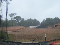
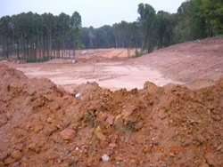
How did so much sediment from the Stockwell Manor construction site come to be deposited dowstream? Aren't erosion and sediment controls such as the super silt fence, riprap, and sedimentation basins in the pictures below supposed to prevent, or at least greatly reduce, such problems?
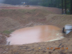
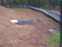
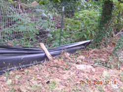
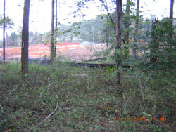
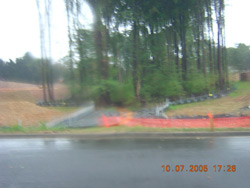
They are, and, with a few exceptions such as a sagging silt fence along Great Falls St. (below left), in an area a considerable distance from the stream and apparently well protected by check dams, and, more alarming, a sagging silt fence and looming pile of topsoil very close to Burke's Spring itself (below right), both observed on October 10, the erosion and sediment controls observable from adjacent streets and properties appeared to be in place and functioning as designed on both Oct. 7th and Oct. 10th. In fact, at the time the pictures above and on page 2 of this narrative were taken, water hadn't yet reached the level at which it would flow through the outlet structures in the sedimentation basins, past the riprap, and into the stream. However, the stream was already running orange, suggesting that runoff from the site was bypassing the sedimentation basins and flowing directly into the stream. Whether this represents a failure in the design of the sediment controls, or whether the basins were designed to catch flow only from certain areas, with silt fences intended to take care of the rest, we don't know.
So where does the problem lie? Clearly, all that sediment was coming from somewhere on the Stockwell Manor site. It's possible that grading was at fault, and flow that was meant to be directed to the sedimentation basins failed to reach them. It's also possible that silt fences were down or otherwise not functioning on parts of the site not observable from adjoining properties. Or perhaps one row of super silt fence is simply not enough to filter sedimented runoff from a large, active construction site, and additional controls (another row of silt fence, with or without a filtering layer of mulch in between, or some other form of protection) need to be added. Or, as the pictures below suggest, the sedimentation downstream may indicate a problem with the site plan itself. Because Burke's Spring Branch was not recognized as perennial by the County and afforded a full 100 foot Resource Protection Area wooded buffer (see EQAC testimony and resolution on letters page), the developer has been allowed to clear right up to the stream not only in the area of the road crossing (middle and right picture below), but also on the site of the future inline stormwater pond (pictured below left and on pages 2 and 4 of this narrative). While it's impossible to judge precisely from a distance, the cleared and protected areas currently on the site appear to correspond roughly in outline, location, and size with those depicted on the site plan. Unfortunately, even the full 100-foot RPA afforded to perennial streams is quite narrow when viewed in the context of a many-acre construction site. The narrower EQC (Environmental Quality Corridor) buffers indicated on the plan, pictured below, and cited at public hearings not only by the developer's representatives but also by staff and public officials as evidence of a commitment to protecting the stream, may simply be inadequate to that job.
So what can be done about these problems? We reported the sedimentation to the County's Sites Inspections Division and to our elected and appointed representatives in an email which also asked for further information about the causes of the problem, and received a reply from Rosemary Ryan of Supervisor Joan DuBois' office. An extensive cleanup effort, described by FOBSB members Marie Shiels-Djouadi and Jack Dent in an email to their McLean Greens neighbors, is now underway; we'll post pictures of the results as soon as time allows. If you have further information about this event, and/or if you observe additional problems on the Stockwell Manor or any Fairfax County construction site, please call the Fairfax County Code Enforcement Division's 24-hour hotline at (703) 324-1937. The information you provide will be entered into the County's formal complaint database, and forwarded to a site inspector for investigation. Please also consider attending the public forum at which the County's draft plan for the Middle Potomac Watersheds will be discussed (see announcement on FOBSB home page); this forum provides a chance to see how the County proposes to protect Pimmit Run and its tributaries, and to address problems, including several in the Burke's Spring Branch watershed, identified at earlier fora and by the steering committee. Since the plan addresses County policies as well as specific problems and projects, the forum can also provide an opportunity to address some of the larger questions raised by this incident: whether Fairfax County's current provisions for protecting streams during and after development are adequate, or whether the process, from Area Plan reviews and rezoning hearings on, is in need of reform. |
|||||||||
| Home | Watershed Map & Areas of Interest/Concern |
Historic Watershed Maps | Activities | Contact/Join Us |
All items copyright © 2003-2005
Friends of Burke's Spring Branch unless another source is noted.
Copyright for items with identified authorship remains with the
author(s); historical and other documents reproduced here are, to
the best knowledge of the webmaster, in the public domain. Items
under Friends of Burke's Spring Branch copyright may be reproduced
for nonprofit research or educational use as long as this copyright
notice is included. Please direct comments and questions to Cathy
Saunders. |