
| Home | |
| Who We Are | |
| Historic
Watershed Maps |
|
| Activities |
|
| you are here: home > historic watershed maps > 1917 usgs topo map | |
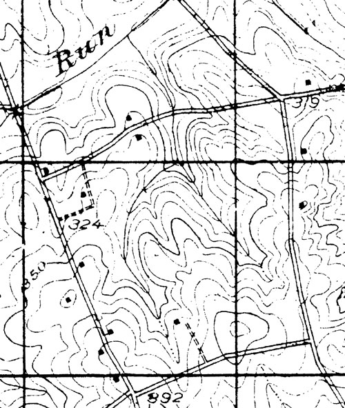
The two images on this page are taken from a c. 1917 USGS topographic map. The full map is available in the Local History room of the Falls Church Public Library (call # VaC/CA/1917/ L.002). The detail immediately below shows the Burke's Spring Branch watershed and a bit of the surrounding area. Haycock Road runs along the bottom of the map, with Great Falls St. on the left, Westmoreland on the right, and Kirby near the top. You can see the "run" part of a label for Pimmit Run just above the line indicating the stream. The Dye/Burke house is at the center of the map, near the bottom; parallel dashed lines trace its dirt driveway, which, until the houses at the end of Montour were built in the 1970s, connected to Haycock Rd. The western fork of Burke's Spring Branch is visible just to the left of the house. Burke's Spring itself is not depicted, but note that the stream is drawn as intermittent (interrupted line) above the point where the flow from the spring joins the channel, and perennial (solid line) below. The eastern fork is also depicted as intermittent in its uppermost reaches, and perennial for the majority of its length. This map also offers insight into the fate of older houses in the watershed. There are 14 houses pictured below (one is slightly hidden by the 3 of the 392 toward the bottom of the map). Three of them, the Dye/Burke house, the Smith/Walker house (almost directly across Great Falls St. from the Dye/Burke House), and one of the Kirby homesteads (upper right, just above the 319) were built before the Civil War, and show up on maps of that era. The others were built in the late 19th or early 20th century. Of the pre-Civil-War houses, only one, the c. 1808 Dye/Burke house, is still standing, and it is threatened by the Winchester Homes development. Of the 9 late 19th/early 20th century houses, 6 are still standing, and one, the c. 1910 McConvey house, is threatened by the Winchester development.
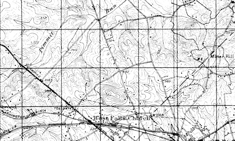
The next image shows the Burke's Spring Branch watershed in a larger context. To the west of the Haycock/Longfellow block, you can see the original paths of Thrift's Spring Branch, Darne's Spring Branch, and Bridge Branch, Pimmit Run tributaries which have been severely impacted by the construction of highways, houses, and the Metro, and are now mostly carried in underground pipes and concrete culverts. Darrell Branch, the Pimmit Run tributary visible to the east, is also piped for a considerable portion of its length, though parts are still above ground. Just south of the Haycock/Longfellow block, you can see the beginnings of tributaries of Four Mile Run, the major stream to the south of Pimmit Run. Some of this land may now drain into Burke's Spring Branch and Pimmit Run through the stormwater channels that run under Haycock Rd. At the very bottom of the image, you can see the Washington & Old Dominion railroad, now the W&OD trail.
|
|
| Home | Watershed Map & Areas of Interest/Concern |
Historic Watershed Maps | Activities | Contact/Join Us |
All items copyright © 2003-2005
Friends of Burke's Spring Branch unless another source is noted.
Copyright for items with identified authorship remains with the
author(s); historical and other documents reproduced here are, to
the best knowledge of the webmaster, in the public domain. Items
under Friends of Burke's Spring Branch copyright may be reproduced
for nonprofit research or educational use as long as this copyright
notice is included. Please direct comments and questions to Cathy
Saunders. |