
Erosion from Stockwell Manor Site --
October 7 & 8, 2005
| Home | |
| Who We Are | |
| Historic
Watershed Maps |
|
| Activities |
|
| you are here: home > stockwell manor erosion page 4 | |||||||
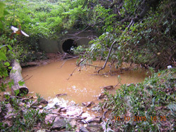
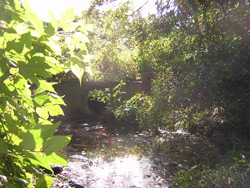
Evidence of sedimentation continued upstream. The pool just below the outlet to the McLean Greens stormwater pond was orange and cloudy (left), a decided contrast to its appearance in earlier years, before construction began (right):
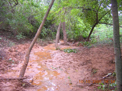
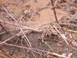
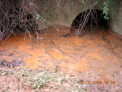
Above the McLean Greens stormwater pond, on the community's common land, the channel of the stream was spread with thick, sticky clay (left). This section of the stream, bounded by a steep berm on one side, and receiving at its upstream end runoff both from undetained neighborhoods and from what appears to be the outlet to stormwater drains in nearby streets, has had ongoing problems with sedimentation. However, on October 10, the contrast between the existing earth and new deposits of red clay was clearly visible (right):
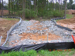
Sediment was also visible both downstream of Hutchison St., just below the construction site (left), and upstream of the Hutchison St., on the Stockwell Manor site itself, where riprap currently fills the stream channel in the area that will eventually become an inline stormwater pond (right):
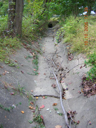
As during the storm, there was no evidence of sediment in the concrete stormwater channels downstream of Crutchfield St.:
So, the source of the problem seems to be the Stockwell Manor site, and the problem seems to be fairly serious, with consequences not only for immediate neighbors, but also for the larger Chesapeake Bay watershed and beyond. A significant amount of sediment is being deposited both on downstream neighbors' land, making common areas unattractive and difficult to care for, and in the stream channel itself, significantly inhibiting the stream's ecological function by filling in the small spaces between rocks. In a healthy stream, these spaces provide habitat for some of the smallest members of the stream ecosystem, organisms that break down leaves and other debris, starting a food chain that continues into the Potomac, the Chesapeake Bay, and, eventually, the Atlantic Ocean. When the spaces, and the organisms that inhabit them, are reduced or eliminated, the food chain breaks down. What, exactly, caused this problem? And what can be done to solve it? We don't have all the answers yet, but the next page offers a few ideas. |
|||||||
| Home | Watershed Map & Areas of Interest/Concern |
Historic Watershed Maps | Activities | Contact/Join Us |
All items copyright © 2003-2005
Friends of Burke's Spring Branch unless another source is noted.
Copyright for items with identified authorship remains with the
author(s); historical and other documents reproduced here are, to
the best knowledge of the webmaster, in the public domain. Items
under Friends of Burke's Spring Branch copyright may be reproduced
for nonprofit research or educational use as long as this copyright
notice is included. Please direct comments and questions to Cathy
Saunders. |